DORIAN STRENGTHENS TO A CATEGORY 4 HURRICANE
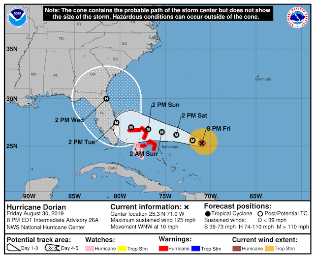
A Hurricane Watch is in continues for the Northwest Bahamas excluding Andros Island. A Hurricane Watch continues for Andros Island. Hurricane conditions are expected in the hurricane warning area in the northwestern Bahamas by Sunday, with tropical storm winds beginning Saturday night.
Interests in South and Central Florida should monitor the progress of Dorian. Life-threatening storm surge and devastating hurricane-force winds are likely along portions of the Florida east coast by early next week, but since Dorian is forecast to slow down and turn northward near the coast, it is too soon to determine when or where the highest surge and winds will occur.
Residents should have their hurricane plan in place, know if they are in a hurricane evacuation zone, and listen to advice given by local emergency officials.
Hurricane Dorian is centered as of 8:30 p.m. AST/EDT about 575 miles (925 km) east of West Palm Beach, Florida. Dorian is moving toward the west-northwest near 10 mph (17 km/h). A slower west-northwestward to westward motion should begin tonight and continue into early next week. On this track, the core of Dorian should move over the Atlantic well north of the southeastern and central Bahamas tonight and tomorrow, be near or over the northwestern Bahamas on Sunday, and be near the Florida east coast late Monday.
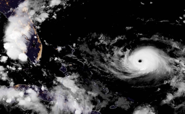
Data from the NOAA Hurricane Hunters indicate that Dorian has strengthened to an extremely dangerous category 4 hurricane with maximum sustained winds near 130 mph (215 km/h). Hurricane-force winds extend outward up to 30 miles (45 km) from the center and tropical-storm-force winds extend outward up to 115 miles (185 km). Additional strengthening is forecast, and Dorian is anticipated to remain an extremely dangerous hurricane while it moves near the northwestern Bahamas and approaches the Florida peninsula into early next week.
A life-threatening storm surge will raise water levels by as much as 10 to 15 feet above normal tide levels in areas of onshore winds in the northwestern Bahamas. Near the coast, the surge will be accompanied by large and destructive waves.
Dorian is expected to produce the following rainfall accumulations this weekend into the middle of next week:
Northwest Bahamas...10 to 15 inches, isolated 20 inches.
Coastal sections of the southeast United States...6 to 12 inches, isolated 18 inches.
Central Bahamas...2 to 4 inches, isolated 6 inches.
This rainfall may cause life-threatening flash floods.