Issued at 200 PM AST Mon Sep 18 2017
000
WTNT35 KNHC 181746
TCPAT5
BULLETIN
Hurricane Maria Intermediate Advisory Number 9A
NWS National Hurricane Center Miami FL
AL152017
200 PM AST Mon Sep 18 2017
...MARIA CONTINUING TO STRENGTHEN...
...THE EYE IS EXPECTED TO MOVE THROUGH THE LEEWARD ISLANDS LATE THIS
AFTERNOON OR THIS EVENING...
SUMMARY OF 200 PM AST...1800 UTC...INFORMATION
----------------------------------------------
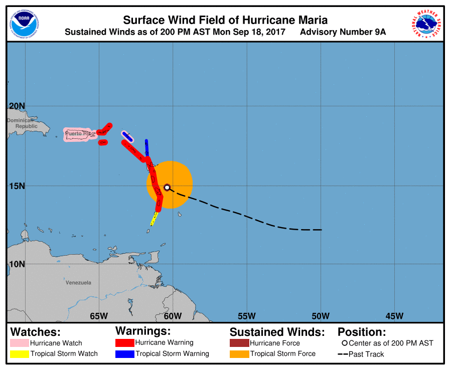
LOCATION...14.9N 60.4W
ABOUT 45 MI...70 KM ENE OF MARTINIQUE
ABOUT 70 MI...115 KM ESE OF DOMINICA
MAXIMUM SUSTAINED WINDS...125 MPH...200 KM/H
PRESENT MOVEMENT...WNW OR 285 DEGREES AT 10 MPH...17 KM/H
MINIMUM CENTRAL PRESSURE...956 MB...28.23 INCHES
WATCHES AND WARNINGS
--------------------
CHANGES WITH THIS ADVISORY:
The Government of Barbados has discontinued the Tropical Storm
Watch for Barbados.
SUMMARY OF WATCHES AND WARNINGS IN EFFECT:
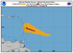
A Hurricane Warning is in effect for...
* Guadeloupe
* Dominica
* St. Kitts, Nevis, and Montserrat
* Martinique
* St. Lucia
* U.S. Virgin Islands
* British Virgin Islands
A Tropical Storm Warning is in effect for...
* Antigua and Barbuda
* Saba and St. Eustatius
* St. Maarten
* Anguilla
A Hurricane Watch is in effect for...
* Puerto Rico, Vieques, and Culebra
* Saba and St. Eustatius
* St. Maarten
* St. Martin and St. Barthelemy
* Anguilla
A Tropical Storm Watch is in effect for...
* St. Vincent and the Grenadines
A Hurricane Warning means that hurricane conditions are expected
somewhere within the warning area. Preparations to protect life and
property should be rushed to completion.
A Tropical Storm Warning means that tropical storm conditions are
expected somewhere within the warning area.
A Hurricane Watch means that hurricane conditions are possible
within the watch area. A watch is typically issued 48 hours
before the anticipated first occurrence of tropical-storm-force
winds, conditions that make outside preparations difficult or
dangerous.
A Tropical Storm Watch means that tropical storm conditions are
possible within the watch area, generally within 48 hours.
Interests elsewhere in the Lesser Antilles and the Dominican
Republic should monitor the progress of this system. Hurricane
Warnings will likely be issued for Puerto Rico and the nearby
islands this afternoon.
For storm information specific to your area in the United
States, including possible inland watches and warnings, please
monitor products issued by your local National Weather Service
forecast office. For storm information specific to your area outside
the United States, please monitor products issued by your national
meteorological service.
DISCUSSION AND 48-HOUR OUTLOOK
------------------------------
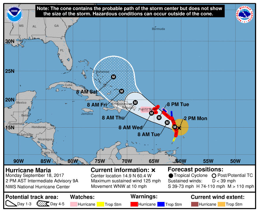
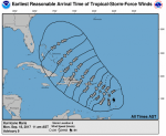
At 200 PM AST (1800 UTC), the eye of Hurricane Maria was located
by the French radar on Martinique near latitude 14.9 North,
longitude 60.4 West. Maria is moving toward the west-northwest near
10 mph (17 km/h), and this motion with some decrease in forward
speed is expected through Tuesday night. On the forecast track, the
center of Maria will move across the Leeward Islands late today and
tonight, over the extreme northeastern Caribbean Sea Tuesday and
Tuesday night, and approach Puerto Rico and the Virgin Islands on
Wednesday.
Reports from an Air Force Reserve Hurricane Hunter aircraft
indicate that maximum sustained winds have increased to near 125 mph
(200 km/h) with higher gusts. Maria is a category 3 hurricane on
the Saffir-Simpson Hurricane Wind Scale. Additional rapid
strengthening is forecast during the next 48 hours, and Maria is
expected to be a dangerous major hurricane as it moves through the
Leeward Islands and the northeastern Caribbean Sea.
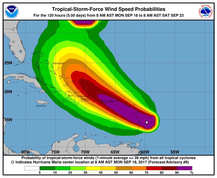
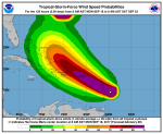
Hurricane-force winds extend outward up to 15 miles (30 km) from
the center and tropical-storm-force winds extend outward up to 125
miles (205 km).
The minimum central pressure estimated from the Hurricane Hunter
aircraft data is 956 mb (28.23 inches).
HAZARDS AFFECTING LAND
----------------------
WIND: Hurricane conditions are first expected within portions of
the Leeward Islands by late today, with tropical storm conditions
beginning shortly. Hurricane conditions should spread through the
remainder of the hurricane warning area tonight through Tuesday
night. Hurricane conditions are possible within the hurricane watch
area Tuesday through Wednesday, with tropical storm conditions
possible later today or tonight. Tropical storm conditions are
possible in the tropical storm watch area through tonight.
STORM SURGE: A dangerous storm surge accompanied by large and
destructive waves will raise water levels by as much as 6 to 9 feet
above normal tide levels in the hurricane warning area near where
the center of Maria moves across the Leeward Islands and the
British Virgin Islands.
The combination of a dangerous storm surge and the tide will cause
normally dry areas near the coast to be flooded by rising waters
moving inland from the shoreline. The water is expected to reach
the following heights above ground if the peak surge occurs at the
time of high tide...
Puerto Rico and the U.S. Virgin Islands...6 to 9 ft
The deepest water will occur along the immediate coast near and to
the north and east of the landfall location, where the surge will be
accompanied by large and destructive waves. Surge-related
flooding depends on the relative timing of the surge and the tidal
cycle, and can vary greatly over short distances. For information
specific to your area, please see products issued by your local
National Weather Service forecast office.
RAINFALL: Maria is expected to produce total rain accumulations of
6 to 12 inches with isolated maximum amounts of 20 inches across the
central and southern Leeward Islands, and the U.S. and British
Virgin Islands through Wednesday night. Rainfall amounts of 6 to 12
inches with isolated maximum amounts of 25 inches are expected
across Puerto Rico. Maria is also expected to produce total rain
accumulations of 2 to 4 inches with isolated maximum amounts of 8
inches over the remaining northern Leeward Islands from Barbuda to
Anguilla, eastern portions of the Dominican Republic, as well as the
Windward Islands and Barbados. Rainfall on all of these islands
could cause life-threatening flash floods and mudslides.
SURF: Swells generated by Maria are affecting the Lesser Antilles.
These swells are likely to cause life-threatening surf and rip
current conditions. Please consult products from your local
weather office.
NEXT ADVISORY
-------------
Next complete advisory at 500 PM AST.
$
Forecaster Beven
Issued at 200 PM AST Mon Sep 18 2017
000WTNT35 KNHC 181746TCPAT5
BULLETINHurricane Maria Intermediate Advisory Number 9ANWS National Hurricane Center Miami FL
AL152017200 PM AST Mon Sep 18 2017
...MARIA CONTINUING TO STRENGTHEN......THE EYE IS EXPECTED TO MOVE THROUGH THE LEEWARD ISLANDS LATE THISAFTERNOON OR THIS EVENING...
SUMMARY OF 200 PM AST...1800 UTC...I
NFORMATION
----------------------------------------------
LOCATION...14.9N 60.4WABOUT 45 MI...70 KM ENE OF MARTINIQUEABOUT 70 MI...115 KM ESE OF DOMINICAMAXIMUM SUSTAINED WINDS...125 MPH...200 KM/HPRESENT MOVEMENT...WNW OR 285 DEGREES AT 10 MPH...17 KM/HMINIMUM CENTRAL PRESSURE...956 MB...28.23 INCHES
WATCHES AND WARNINGS
--------------------
CHANGES WITH THIS ADVISORY:
The Government of Barbados has discontinued the Tropical StormWatch for Barbados.
SUMMARY OF WATCHES AND WARNINGS IN EFFECT:
A Hurricane Warning is in effect for...* Guadeloupe* Dominica* St. Kitts, Nevis, and Montserrat* Martinique* St. Lucia* U.S. Virgin Islands* British Virgin Islands
A Tropical Storm Warning is in effect for...
* Antigua and Barbuda* Saba and St. Eustatius* St. Maarten* Anguilla
A Hurricane Watch is in effect for...
* Puerto Rico, Vieques, and Culebra* Saba and St. Eustatius* St. Maarten* St. Martin and St. Barthelemy* Anguilla.
A Tropical Storm Watch is in effect for...
* St. Vincent and the Grenadines
A Hurricane Warning means that hurricane conditions are expectedsomewhere within the warning area. Preparations to protect life andproperty should be rushed to completion.
A Tropical Storm Warning means that tropical storm conditions areexpected somewhere within the warning area.
A Hurricane Watch means that hurricane conditions are possiblewithin the watch area. A watch is typically issued 48 hoursbefore the anticipated first occurrence of tropical-storm-forcewinds, conditions that make outside preparations difficult ordangerous.
A Tropical Storm Watch means that tropical storm conditions arepossible within the watch area, generally within 48 hours.
Interests elsewhere in the Lesser Antilles and the DominicanRepublic should monitor the progress of this system. HurricaneWarnings will likely be issued for Puerto Rico and the nearbyislands this afternoon.
For storm information specific to your area in the UnitedStates, including possible inland watches and warnings, pleasemonitor products issued by your local National Weather Serviceforecast office. For storm information specific to your area outsidethe United States, please monitor products issued by your nationalmeteorological service.
DISCUSSION AND 48-HOUR OUTLOOK
------------------------------
At 200 PM AST (1800 UTC), the eye of Hurricane Maria was locatedby the French radar on Martinique near latitude 14.9 North,longitude 60.4 West. Maria is moving toward the west-northwest near10 mph (17 km/h), and this motion with some decrease in forwardspeed is expected through Tuesday night. On the forecast track, thecenter of Maria will move across the Leeward Islands late today andtonight, over the extreme northeastern Caribbean Sea Tuesday andTuesday night, and approach Puerto Rico and the Virgin Islands onWednesday.
Reports from an Air Force Reserve Hurricane Hunter aircraftindicate that maximum sustained winds have increased to near 125 mph(200 km/h) with higher gusts. Maria is a category 3 hurricane onthe Saffir-Simpson Hurricane Wind Scale. Additional rapidstrengthening is forecast during the next 48 hours, and Maria isexpected to be a dangerous major hurricane as it moves through theLeeward Islands and the northeastern Caribbean Sea.
Hurricane-force winds extend outward up to 15 miles (30 km) fromthe center and tropical-storm-force winds extend outward up to 125miles (205 km).
The minimum central pressure estimated from the Hurricane Hunteraircraft data is 956 mb (28.23 inches).
HAZARDS AFFECTING LAND----------------------WIND:
Hurricane conditions are first expected within portions ofthe Leeward Islands by late today, with tropical storm conditionsbeginning shortly. Hurricane conditions should spread through theremainder of the hurricane warning area tonight through Tuesdaynight. Hurricane conditions are possible within the hurricane watcharea Tuesday through Wednesday, with tropical storm conditionspossible later today or tonight. Tropical storm conditions arepossible in the tropical storm watch area through tonight.
STORM SURGE: A dangerous storm surge accompanied by large anddestructive waves will raise water levels by as much as 6 to 9 feetabove normal tide levels in the hurricane warning area near wherethe center of Maria moves across the Leeward Islands and theBritish Virgin Islands.
The combination of a dangerous storm surge and the tide will causenormally dry areas near the coast to be flooded by rising watersmoving inland from the shoreline. The water is expected to reachthe following heights above ground if the peak surge occurs at thetime of high tide...
Puerto Rico and the U.S. Virgin Islands...6 to 9 ft
The deepest water will occur along the immediate coast near and tothe north and east of the landfall location, where the surge will beaccompanied by large and destructive waves. Surge-relatedflooding depends on the relative timing of the surge and the tidalcycle, and can vary greatly over short distances. For informationspecific to your area, please see products issued by your localNational Weather Service forecast office.
RAINFALL: Maria is expected to produce total rain accumulations of6 to 12 inches with isolated maximum amounts of 20 inches across thecentral and southern Leeward Islands, and the U.S. and BritishVirgin Islands through Wednesday night. Rainfall amounts of 6 to 12inches with isolated maximum amounts of 25 inches are expectedacross Puerto Rico. Maria is also expected to produce total rainaccumulations of 2 to 4 inches with isolated maximum amounts of 8inches over the remaining northern Leeward Islands from Barbuda toAnguilla, eastern portions of the Dominican Republic, as well as theWindward Islands and Barbados. Rainfall on all of these islandscould cause life-threatening flash floods and mudslides.
SURF: Swells generated by Maria are affecting the Lesser Antilles.These swells are likely to cause life-threatening surf and ripcurrent conditions. Please consult products from your localweather office.
NEXT ADVISORY
-------------
Next complete advisory at 500 PM AST.
Forecaster Beven
Click here to read more at The National Hurricane Center