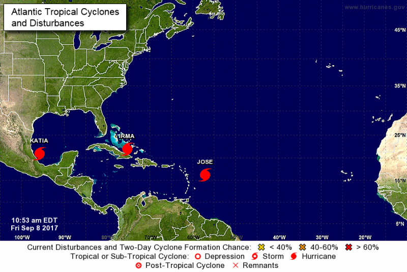
Issued at 1100 AM EDT Fri Sep 08 2017
000
WTNT31 KNHC 081450
TCPAT1
BULLETIN
Hurricane Irma Advisory Number 38
NWS National Hurricane Center Miami FL
AL112017
1100 AM EDT Fri Sep 08 2017
...EYE OF HURRICANE IRMA MONITORED BY HURRICANE HUNTER PLANES AND
CUBAN RADARS...
...HURRICANE CONDITIONS SPREADING WESTWARD OVER PORTIONS OF CUBA AND
THE CENTRAL BAHAMAS...
SUMMARY OF 1100 AM EDT...1500 UTC...INFORMATION
-----------------------------------------------
LOCATION...22.0N 75.3W
ABOUT 270 MI...435 KM E OF CAIBARIEN CUBA
ABOUT 405 MI...655 KM SE OF MIAMI FLORIDA
MAXIMUM SUSTAINED WINDS...150 MPH...240 KM/H
PRESENT MOVEMENT...WNW OR 285 DEGREES AT 14 MPH...22 KM/H
MINIMUM CENTRAL PRESSURE...927 MB...27.38 INCHES
WATCHES AND WARNINGS
--------------------
CHANGES WITH THIS ADVISORY:
The Storm Surge Warning has been extended from Jupiter Inlet
northward to Sebastian Inlet and from Bonita Beach northward to
Venice.
A Storm Surge Watch has been issued from north of Sebastian Inlet to
Ponce Inlet.
The Hurricane Watch has been extended northward along the east
coast of Florida to the Flagler/Volusia County Line, and along the
west coast of Florida to Anclote River.
SUMMARY OF WATCHES AND WARNINGS IN EFFECT:
A Storm Surge Warning is in effect for...
* Sebastian Inlet southward around the Florida peninsula to Venice
* Florida Keys
A Storm Surge Watch is in effect for...
* North of Sebastian Inlet to Ponce Inlet
A Hurricane Warning is in effect for...
* Jupiter Inlet southward around the Florida peninsula to Bonita
Beach
* Florida Keys
* Lake Okeechobee
* Florida Bay
* Southeastern Bahamas and the Turks and Caicos Islands
* Cuban provinces of Camaguey, Ciego de Avila, Sancti Spiritus, and
Villa Clara
* Central Bahamas
* Northwestern Bahamas
A Hurricane Watch is in effect for...
* North of Jupiter Inlet to the Flagler/Volusia County Line
* North of Bonita Beach to Anclote River
* Cuban provinces of Guantanamo, Holguin, Las Tunas and Matanzas
A Tropical Storm Warning is in effect for...
* Cuban provinces of Guantanamo, Holguin, and Las Tunas
A Storm Surge Warning means there is a danger of life-threatening
inundation, from rising water moving inland from the coastline,
during the next 36 hours in the indicated locations. For a
depiction of areas at risk, please see the National Weather
Service Storm Surge Watch/Warning Graphic, available at
hurricanes.gov. This is a life-threatening situation. Persons
located within these areas should take all necessary actions to
protect life and property from rising water and the potential for
other dangerous conditions. Promptly follow evacuation and other
instructions from local officials.
A Storm Surge Watch means there is a possibility of life-
threatening inundation, from rising water moving inland from the
coastline, in the indicated locations during the next 48 hours.
For a depiction of areas at risk, please see the National Weather
Service Storm Surge Watch/Warning Graphic, available at
hurricanes.gov.
A Hurricane Warning means that hurricane conditions are expected
somewhere within the warning area. Preparations to protect life and
property should be rushed to completion.
A Hurricane Watch means that hurricane conditions are possible
within the watch area. A watch is typically issued 48 hours
before the anticipated first occurrence of tropical-storm-force
winds, conditions that make outside preparations difficult or
dangerous.
A Tropical Storm Warning means that tropical storm conditions are
expected somewhere within the warning area.
Interests elsewhere in Cuba, Florida, and the southeastern United
States should monitor the progress of Irma.
For storm information specific to your area in the United States,
including possible inland watches and warnings, please monitor
products issued by your local National Weather Service forecast
office. For storm information specific to your area outside the
United States, please monitor products issued by your national
meteorological service.
DISCUSSION AND 48-HOUR OUTLOOK
------------------------------
At 1100 AM EDT (1500 UTC), the distinct eye of Hurricane Irma was
located near latitude 22.0 North, longitude 75.3 West. Irma is
moving toward the west-northwest near 14 mph (22 km/h), and this
motion is expected to continue for the next day or so with a
decrease in forward speed. A turn toward the northwest is expected
by late Saturday. On the forecast track, the eye of Irma should
move near the north coast of Cuba and the central Bahamas today and
Saturday, and be near the Florida Keys and the southern Florida
Peninsula Sunday morning.
Maximum sustained winds are near 150 mph (240 km/h) with higher
gusts. Irma is a category 4 hurricane on the Saffir-Simpson
Hurricane Wind Scale. Some fluctuations in intensity are likely
during the next day or two, but Irma is forecast to remain a
powerful category 4 hurricane as it approaches Florida.
Hurricane-force winds extend outward up to 70 miles (110 km) from
the center and tropical-storm-force winds extend outward up to 185
miles (295 km).
The latest minimum central pressure reported by both Air Force
and NOAA Hurricane Hunter planes was 927 mb (27.38 inches).
HAZARDS AFFECTING LAND
----------------------
STORM SURGE: The combination of a dangerous storm surge and the
tide will cause normally dry areas near the coast to be flooded by
rising waters moving inland from the shoreline. The water is
expected to reach the following HEIGHTS ABOVE GROUND if the peak
surge occurs at the time of high tide...
SW Florida from Captiva to Cape Sable...6 to 12 ft
Jupiter Inlet to Cape Sable including the Florida Keys...5 to 10 ft
Ponce Inlet to Jupiter Inlet...3 to 6 ft
Venice to Captiva...3 to 6 ft
The deepest water will occur along the immediate coast in areas of
onshore winds, where the surge will be accompanied by large and
destructive waves. Surge-related flooding depends on the relative
timing of the surge and the tidal cycle, and can vary greatly over
short distances. For information specific to your area, please see
products issued by your local National Weather Service forecast
office.
The combination of a life-threatening storm surge and large breaking
waves will raise water levels ABOVE NORMAL TIDE LEVELS by the
following amounts within the hurricane warning area near and to the
north of the center of Irma. Near the coast, the surge will be
accompanied by large and destructive waves.
Turks and Caicos Islands...15 to 20 ft
Southeastern and central Bahamas...15 to 20 ft
Northwestern Bahamas...5 to 10 ft
Northern coast of Haiti and the Gulf of Gonave...1 to 3 ft
Northern coast of Cuba in the warning area...5 to 10 ft
WIND: Hurricane conditions are occurring on the Turks and Caicos
Islands, with tropical storm and hurricane conditions ongoing in the
southeastern Bahamas. These conditions will move into the central
Bahamas later today. Hurricane conditions are expected within the
hurricane warning area along the north coast of Cuba late today and
Saturday. Hurricane conditions are expected in the northwestern
Bahamas tonight and Saturday, and in portions of southern Florida
and the Florida Keys Saturday night or early Sunday.
Hurricane conditions are possible within the watch area in Florida
by Sunday, with tropical storm conditions possible by late Saturday.
RAINFALL: Irma is expected to produce the following rain
accumulations through Tuesday night:
Dominican Republic and Haiti...additional 1 to 4 inches.
Turks and Caicos...additional 2 to 4 inches.
Southern Bahamas and northern Cuba...10 to 15 inches, isolated 20
inches.
Southern Cuba...4 to 8 inches, isolated 12 inches.
Jamaica...1 to 2 inches.
The upper Florida Keys into southeast Florida...10 to 15 inches,
isolated 20 inches.
Lower Florida Keys...4 to 8 inches.
Eastern Florida northward into coastal Georgia...8 to 12 inches,
isolated 16 inches.
Western Florida peninsula...4 to 8 inches, isolated 12 inches.
Much of Georgia...South Carolina...and Western North Carolina...3 to
6 inches.
In all areas this rainfall may cause life-threatening flash floods
and, in some areas, mudslides.
SURF: Swells generated by Irma are affecting Puerto Rico, the
Virgin Islands, the southeastern Bahamas, the Turks and Caicos
Islands, the northern coast of the Dominican Republic, and should
start affecting portions of the southeast coast of the United States
later today and tonight. These swells are likely to cause
life-threatening surf and rip current conditions. Please consult
products from your local weather office.
NEXT ADVISORY
-------------
Next intermediate advisory at 200 PM EDT.
Next complete advisory at 500 PM EDT.
$
Forecaster Avila
Issued at 1100 AM EDT Fri Sep 08 2017
000WTNT31 KNHC 081450TCPAT1
BULLETINHurricane Irma Advisory Number 38NWS National Hurricane Center Miami FL
AL1120171100 AM EDT Fri Sep 08 2017
...EYE OF HURRICANE IRMA MONITORED BY HURRICANE HUNTER PLANES ANDCUBAN RADARS......HURRICANE CONDITIONS SPREADING WESTWARD OVER PORTIONS OF CUBA ANDTHE CENTRAL BAHAMAS...
SUMMARY OF 1100 AM EDT...1500 UTC...
INFORMATION
-----------------------------------------------
LOCATION...22.0N 75.3WABOUT 270 MI...435 KM E OF CAIBARIEN CUBAABOUT 405 MI...655 KM SE OF MIAMI FLORIDAMAXIMUM SUSTAINED WINDS...150 MPH...240 KM/HPRESENT MOVEMENT...WNW OR 285 DEGREES AT 14 MPH...22 KM/HMINIMUM CENTRAL PRESSURE...927 MB...27.38 INCHES
WATCHES AND WARNINGS--------------------CHANGES WITH THIS ADVISORY:
The Storm Surge Warning has been extended from Jupiter Inletnorthward to Sebastian Inlet and from Bonita Beach northward toVenice.
A Storm Surge Watch has been issued from north of Sebastian Inlet toPonce Inlet.
The Hurricane Watch has been extended northward along the eastcoast of Florida to the Flagler/Volusia County Line, and along thewest coast of Florida to Anclote River.
SUMMARY OF WATCHES AND WARNINGS IN EFFECT:
A Storm Surge Warning is in effect for...
* Sebastian Inlet southward around the Florida peninsula to Venice
* Florida Keys
A Storm Surge Watch is in effect for...
* North of Sebastian Inlet to Ponce Inlet
A Hurricane Warning is in effect for...
* Jupiter Inlet southward around the Florida peninsula to BonitaBeach
* Florida Keys
* Lake Okeechobee
* Florida Bay
* Southeastern Bahamas and the Turks and Caicos Islands
* Cuban provinces of Camaguey, Ciego de Avila, Sancti Spiritus, andVilla Clara
* Central Bahamas* Northwestern Bahamas
A Hurricane Watch is in effect for...* North of Jupiter Inlet to the Flagler/Volusia County Line
* North of Bonita Beach to Anclote River
* Cuban provinces of Guantanamo, Holguin, Las Tunas and Matanzas
A Tropical Storm Warning is in effect for...
* Cuban provinces of Guantanamo, Holguin, and Las Tunas
A Storm Surge Warning means there is a danger of life-threateninginundation, from rising water moving inland from the coastline,during the next 36 hours in the indicated locations. For adepiction of areas at risk, please see the National WeatherService Storm Surge Watch/Warning Graphic, available athurricanes.gov. This is a life-threatening situation. Personslocated within these areas should take all necessary actions toprotect life and property from rising water and the potential forother dangerous conditions. Promptly follow evacuation and otherinstructions from local officials.
A Storm Surge Watch means there is a possibility of life-threatening inundation, from rising water moving inland from thecoastline, in the indicated locations during the next 48 hours.For a depiction of areas at risk, please see the National WeatherService Storm Surge Watch/Warning Graphic, available athurricanes.gov.
A Hurricane Warning means that hurricane conditions are expectedsomewhere within the warning area. Preparations to protect life andproperty should be rushed to completion.
A Hurricane Watch means that hurricane conditions are possiblewithin the watch area. A watch is typically issued 48 hoursbefore the anticipated first occurrence of tropical-storm-forcewinds, conditions that make outside preparations difficult ordangerous.
A Tropical Storm Warning means that tropical storm conditions areexpected somewhere within the warning area.
Interests elsewhere in Cuba, Florida, and the southeastern UnitedStates should monitor the progress of Irma.
For storm information specific to your area in the United States,including possible inland watches and warnings, please monitorproducts issued by your local National Weather Service forecastoffice. For storm information specific to your area outside theUnited States, please monitor products issued by your nationalmeteorological service.
DISCUSSION AND 48-HOUR OUTLOOK
------------------------------
At 1100 AM EDT (1500 UTC), the distinct eye of Hurricane Irma waslocated near latitude 22.0 North, longitude 75.3 West. Irma ismoving toward the west-northwest near 14 mph (22 km/h), and thismotion is expected to continue for the next day or so with adecrease in forward speed. A turn toward the northwest is expectedby late Saturday. On the forecast track, the eye of Irma shouldmove near the north coast of Cuba and the central Bahamas today andSaturday, and be near the Florida Keys and the southern FloridaPeninsula Sunday morning.
Maximum sustained winds are near 150 mph (240 km/h) with highergusts. Irma is a category 4 hurricane on the Saffir-SimpsonHurricane Wind Scale. Some fluctuations in intensity are likelyduring the next day or two, but Irma is forecast to remain apowerful category 4 hurricane as it approaches Florida
Hurricane-force winds extend outward up to 70 miles (110 km) fromthe center and tropical-storm-force winds extend outward up to 185miles (295 km).
The latest minimum central pressure reported by both Air Forceand NOAA Hurricane Hunter planes was 927 mb (27.38 inches).
HAZARDS AFFECTING LAND
----------------------
STORM SURGE: The combination of a dangerous storm surge and thetide will cause normally dry areas near the coast to be flooded byrising waters moving inland from the shoreline. The water isexpected to reach the following HEIGHTS ABOVE GROUND if the peaksurge occurs at the time of high tide...
SW Florida from Captiva to Cape Sable...6 to 12 ftJupiter Inlet to Cape Sable including the Florida Keys...5 to 10 ftPonce Inlet to Jupiter Inlet...3 to 6 ftVenice to Captiva...3 to 6 ft
The deepest water will occur along the immediate coast in areas ofonshore winds, where the surge will be accompanied by large anddestructive waves. Surge-related flooding depends on the relativetiming of the surge and the tidal cycle, and can vary greatly overshort distances. For information specific to your area, please seeproducts issued by your local National Weather Service forecastoffice.
The combination of a life-threatening storm surge and large breakingwaves will raise water levels ABOVE NORMAL TIDE LEVELS by thefollowing amounts within the hurricane warning area near and to thenorth of the center of Irma. Near the coast, the surge will beaccompanied by large and destructive waves.
Turks and Caicos Islands...15 to 20 ftSoutheastern and central Bahamas...15 to 20 ftNorthwestern Bahamas...5 to 10 ftNorthern coast of Haiti and the Gulf of Gonave...1 to 3 ftNorthern coast of Cuba in the warning area...5 to 10 ft
WIND: Hurricane conditions are occurring on the Turks and CaicosIslands, with tropical storm and hurricane conditions ongoing in thesoutheastern Bahamas. These conditions will move into the centralBahamas later today. Hurricane conditions are expected within thehurricane warning area along the north coast of Cuba late today andSaturday. Hurricane conditions are expected in the northwesternBahamas tonight and Saturday, and in portions of southern Floridaand the Florida Keys Saturday night or early Sunday.
Hurricane conditions are possible within the watch area in Floridaby Sunday, with tropical storm conditions possible by late Saturday.
RAINFALL: Irma is expected to produce the following rainaccumulations through Tuesday night:
Dominican Republic and Haiti...additional 1 to 4 inches.Turks and Caicos...additional 2 to 4 inches.Southern Bahamas and northern Cuba...10 to 15 inches, isolated 20inches.Southern Cuba...4 to 8 inches, isolated 12 inches.Jamaica...1 to 2 inches.The upper Florida Keys into southeast Florida...10 to 15 inches,isolated 20 inches.Lower Florida Keys...4 to 8 inches.Eastern Florida northward into coastal Georgia...8 to 12 inches,isolated 16 inches.Western Florida peninsula...4 to 8 inches, isolated 12 inches.Much of Georgia...South Carolina...and Western North Carolina...3 to6 inches.
In all areas this rainfall may cause life-threatening flash floodsand, in some areas, mudslides.
SURF: Swells generated by Irma are affecting Puerto Rico, theVirgin Islands, the southeastern Bahamas, the Turks and CaicosIslands, the northern coast of the Dominican Republic, and shouldstart affecting portions of the southeast coast of the United Stateslater today and tonight. These swells are likely to causelife-threatening surf and rip current conditions. Please consultproducts from your local weather office.
NEXT ADVISORY
-------------
Next intermediate advisory at 200 PM EDT.Next complete advisory at 500 PM EDT.
Forecaster Avila
Click here to read more at The National Hurricane Center