


A developing tropical storm, moving just north of the large islands of the Caribbean, will take aim at the Bahamas and southern Florida into this weekend.
The disturbance, currently dubbed 99L, will continue to move along a west-northwest path.
"We expect 99L to become Tropical Depression Eight and then Tropical Storm Hermine at any time over the next few days," according to AccuWeather Hurricane Expert Dan Kottlowski.
The disturbance has produced tropical storm-force wind gusts between 40 and 50 mph in heavy squalls over some of the northern Caribbean islands and surrounding waters since Wednesday.
The storm is currently about 750 miles southeast of Miami.
In absence of official designation, clusters of intense thunderstorms and rain will continue in the vicinity of 99L.
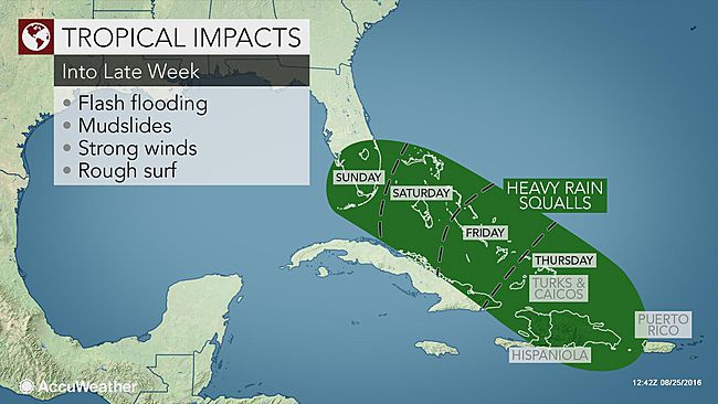
Prior to approaching Florida, 99L will bring a threat of flash flooding, mudslides and rough surf and seas in Puerto Rico, the Dominican Republic and Haiti into Thursday night.
"This has the potential to be a life-threatening situation due to the heavy rain, flooding and mudslide risk in the short term," Kottlowski said.
Sudden, gusty squalls can quickly enrage seas. Small craft should remain in port as a precaution.
These same conditions will spread northwestward over the Turks and Caicos, Cuba and the southern and central Bahamas into Friday and this weekend.
Regardless of whether or not 99L is officially upgraded to Hermine, weather and sea conditions will deteriorate over southern Florida and the Florida Keys on Sunday. The frequency and strength of rip currents and breakers will increase and will pose a threat to bathers.
How dangerous conditions become in terms of storm surge and winds will depend on the strength of the system.
Even in the absence of a hurricane, there is the potential for power outages and property damage due to high winds and flooding. A few waterspouts and tornadoes could be spawned.
If the power goes out, access to fresh tap water may be limited.
As a precaution, people are encouraged to prepare for the storm in advance and gather necessities in case evacuation orders are given.
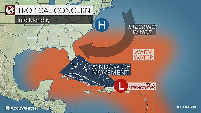
Into this weekend, 99L will open up some distance from the mountainous terrain of the Greater Antilles and move over warm waters. There is the potential for rapid strengthening once the system develops a complete circulation.
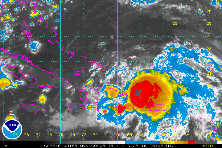
This is a closeup live loop of 99L. (NOAA/Satellite)
If the system becomes a tropical storm, it would be a sign that inhibiting factors such as strong middle-atmosphere disruptive winds have eased. If it becomes a tropical storm, it could become a minimal hurricane due to the same conditions.
Once reaching Florida, the path of the storm will become more questionable into next week, according to AccuWeather Meteorologist Evan Duffey.
Alex Sosnowski
Source: AccuWeather.com
