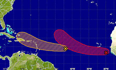
A tropical wave located about 1,100 miles east of the Lesser Antilles is producing disorganized showers and a few thunderstorms and the system is expected to be near Hispaniola and the southeastern Bahamas late this week.
According to the National Hurricane Center in Miami, the proximity of this system to dry air is expected to inhibit significant development during the next few days while the disturbance moves westward to west-northwestward at 15 to 20 mph.
Tropical outlook. (Photo: NHC graphic)
However, environmental conditions could become more conducive for development later in the week, with a 40 percent chance of a tropical cyclone forming during the next five days.
Meanwhile, cloudiness and thunderstorms located over the far eastern Atlantic a few hundred miles southeast of the Cabo Verde Islands are associated with a low pressure area and tropical wave. Environmental conditions are conducive for development, and a tropical depression is likely to form during the next day or two.
However, the system is forecast to move westward and then northwestward over the eastern tropical Atlantic Ocean.
Fiona maintaining tropical storm strength for now.

Tropical Storm Fiona five-day forecast track. (Photo: NHC/NOAA graphic)
At 5:00 pm AST on Sunday, the centre of Tropical Storm Fiona was located about 625 miles northeast of the Leeward Islands, moving toward the west-northwest near 17 mph (28 km/h). This general heading with some decrease in forward speed is expected to continue for the next couple of days.
Maximum sustained winds are near 40 mph (65 km/h) with higher gusts. Some weakening is forecast during the next 24 hours, and Fiona could weaken to a tropical depression by Tuesday.
Tropical-storm-force winds extend outward up to 45 miles (75 km) from the center.
By Caribbean News Now contributor
Source: caribbeannewsnow.com