


TROPICAL STORM FRED INTERMEDIATE ADVISORY NUMBER 4A
NWS NATIONAL HURRICANE CENTER MIAMI FL AL062015
800 PM AST SUN AUG 30 2015
...FRED CONTINUES TO STRENGTHEN...
...EXPECTED TO BRING HURRICANE CONDITIONS TO PORTIONS OF THE CAPE VERDE ISLANDS...
SUMMARY OF 800 PM AST...0000 UTC...INFORMATION
----------------------------------------------
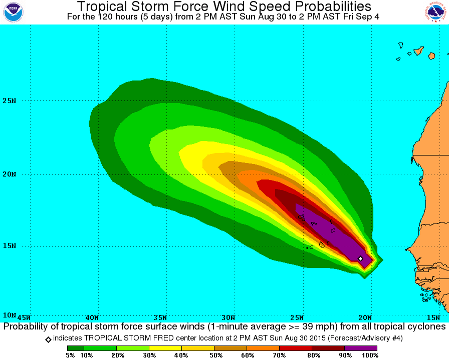
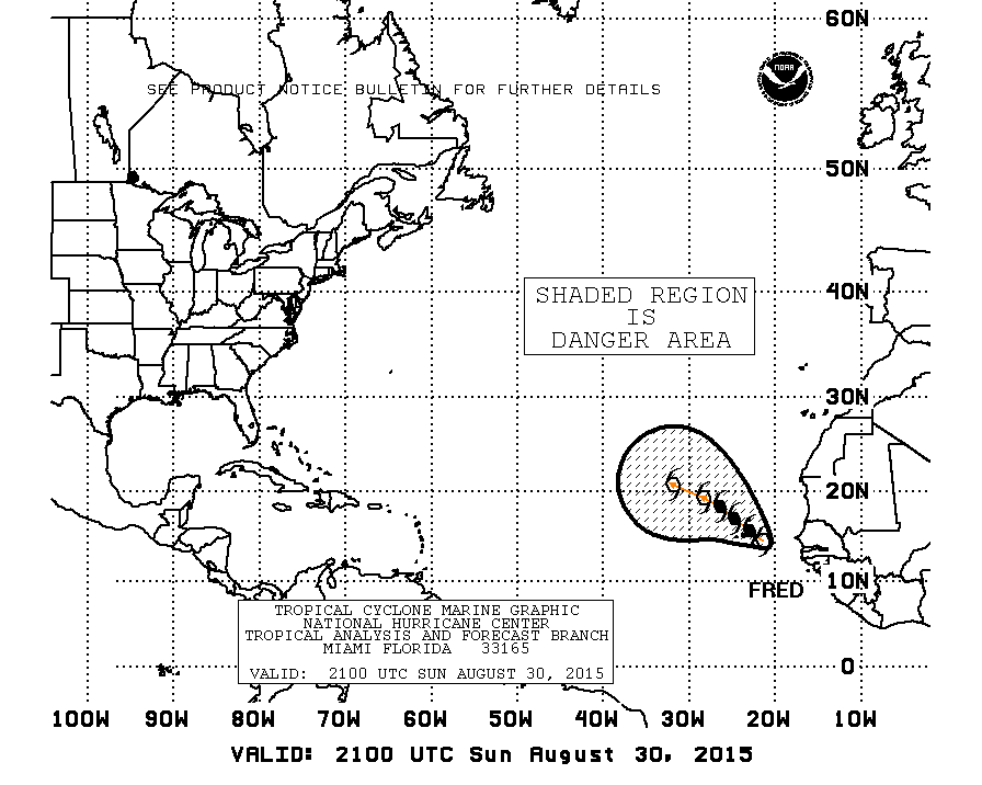
LOCATION...14.9N 21.8W
ABOUT 115 MI...185 KM E OF PRAIA IN THE CAPE VERDE ISLANDS
MAXIMUM SUSTAINED WINDS...70 MPH...110 KM/H
PRESENT MOVEMENT...NW OR 310 DEGREES AT 16 MPH...26 KM/H
MINIMUM CENTRAL PRESSURE...995 MB...29.38 INCHES
WATCHES AND WARNINGS
--------------------
CHANGES WITH THIS ADVISORY:
None
SUMMARY OF WATCHES AND WARNINGS IN EFFECT:
A Hurricane Warning is in effect for...
* Cape Verde Islands
A Hurricane Warning means that hurricane conditions are expected somewhere within the warning area, in this case within the next 12 hours. Preparations to protect life and property should be rushed to completion.
For storm information specific to your area, please monitor products issued by your national meteorological service.
DISCUSSION AND 48-HOUR OUTLOOK
------------------------------
At 800 PM AST (0000 UTC), the center of Tropical Storm Fred was located near latitude 14.9 North, longitude 21.8 West. Fred is moving toward the northwest near 16 mph (26 km/h). A northwestward motion at a slightly slower forward speed is expected through Tuesday. On the forecast track, the center will move near or over some of the Cape Verde Islands early Monday morning.
Maximum sustained winds have increased to near 70 mph (110 km/h) with higher gusts. Strengthening is expected, and Fred is forecast to become a hurricane overnight.
Tropical storm force winds extend outward up to 70 miles (110 km) from the center.
The estimated minimum central pressure is 995 mb (29.38 inches).
HAZARDS AFFECTING LAND
----------------------
WIND: Tropical storm conditions are expected to reach portions of the Cape Verde Islands in a few hours, with hurricane conditions by early Monday morning.
STORM SURGE: A storm surge is expected to produce coastal flooding in areas of onshore winds in the Cape Verde Islands. Near the coast, the surge will be accompanied by large and dangerous waves.
RAINFALL: Fred is expected to produce total rain accumulations of 3 to 5 inches over the Cape Verde Islands, with possible isolated maximum amounts of 8 inches. These rains could produce life-threatening flash flooding and mud slides.
Tropical Storm Fred Reaches 70MPH winds
Sun, Aug 30th 2015, 08:57 PM


Sponsored Ads
