TROPICAL STORM FRED ADVISORY NUMBER 3
NWS NATIONAL HURRICANE CENTER MIAMI FL AL062015
1100 AM AST SUN AUG 30 2015
...FRED STRENGTHENING...
...HURRICANE WARNING ISSUED FOR THE CAPE VERDE ISLANDS...
SUMMARY OF 1100 AM AST...1500 UTC...INFORMATION
-----------------------------------------------
LOCATION...13.4N 19.9W
ABOUT 260 MI...420 KM ESE OF PRAIA IN THE CAPE VERDE ISLANDS
MAXIMUM SUSTAINED WINDS...50 MPH...85 KM/H
PRESENT MOVEMENT...NW OR 310 DEGREES AT 12 MPH...19 KM/H
MINIMUM CENTRAL PRESSURE...1003 MB...29.62 INCHES
WATCHES AND WARNINGS
--------------------
CHANGES WITH THIS ADVISORY:
The Meteorological Service of the Cape Verde Islands has issued a Hurricane Warning for the Cape Verde Islands. This replaces the Tropical Storm Warning and Hurricane Watch that were previously in effect.
SUMMARY OF WATCHES AND WARNINGS IN EFFECT:
A Hurricane Warning is in effect for...
* Cape Verde Islands
A Hurricane Warning means that hurricane conditions are expected somewhere within the warning area, in this case within the next 24 hours. Preparations to protect life and property should be rushed to completion.
For storm information specific to your area, please monitor products issued by your national meteorological service.
DISCUSSION AND 48-HOUR OUTLOOK
------------------------------
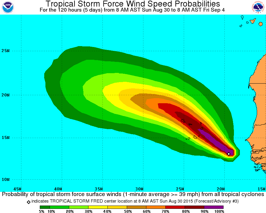
At 1100 AM AST (1500 UTC), the center of Tropical Storm Fred was located near latitude 13.4 North, longitude 19.9 West. Fred is moving toward the northwest near 12 mph (19 km/h) and this general motion is expected to continue through Tuesday. On the forecast track, the center of Fred is expected to move through the Cape Verde Islands on Monday through early Tuesday.
Maximum sustained winds have increased to near 50 mph (85 km/h) with higher gusts. Additional strengthening is expected during the next day or so, and Fred is forecast to become a hurricane before reaching the Cape Verde Islands on Monday.
Tropical storm force winds extend outward up to 60 miles (95 km) from the center.
The estimated minimum central pressure is 1003 mb (29.62 inches).
HAZARDS AFFECTING LAND
----------------------
WIND: Tropical storm conditions are expected to first reach the coast within the warning area by early Monday. Hurricane conditions are expected within a portion of the warning area by Monday afternoon.
STORM SURGE: A storm surge is expected to produce coastal flooding in areas of onshore winds in the Cape Verde Islands. Near the coast, the surge will be accompanied by large and dangerous waves.
RAINFALL: Fred is expected to produce total rain accumulations of 3 to 5 inches over the Cape Verde Islands, with possible isolated maximum amounts of 8 inches on Monday. These rains could produce life-threatening flash flooding and mudslides.

Your Bahamas Online Search Engine
Subscribe today!
Stay up to date with our latest news and product
BahamasLocal.com
Shirley Street, PO Box CB-11567, Nassau, New ProvidenceCall: (242) 698-1300
Sales & Marketing: (242) 698-1300
Telephone (USA): 1-305-677-6594
customerservice@bahamaslocal.com


